Greeter Falls Hiking Guide (Upper vs Lower Falls)
Now, let’s unpack why that distinction matters and how to actually enjoy whichever you choose.
Quick Orientation: Where Greeter Falls Lives
Greeter Falls sits inside South Cumberland State Park, near Monteagle, Tennessee. It’s part of the Fiery Gizzard trail system, which is stunning but not always beginner-friendly. There’s no single “Greeter Falls trailhead”—your starting point changes everything about distance, difficulty, and what you’ll see.
Based on 2026 park information and trail usage patterns:
- Parking at the Greeter Falls lot is limited (around 15 spaces) and fills early on weekends.
- Cell service drops unexpectedly once you descend toward the falls.
- Creek levels can shift within hours after rain, affecting access to Lower Falls.
- No permits are required for day hiking, but a small day-use fee may apply at certain access points.
If you’re coming from Nashville, Chattanooga, or Huntsville, plan for about a 90-minute drive. The payoff is worth it—but only if you go in prepared.
Upper vs Lower: What You’re Actually Signing Up For
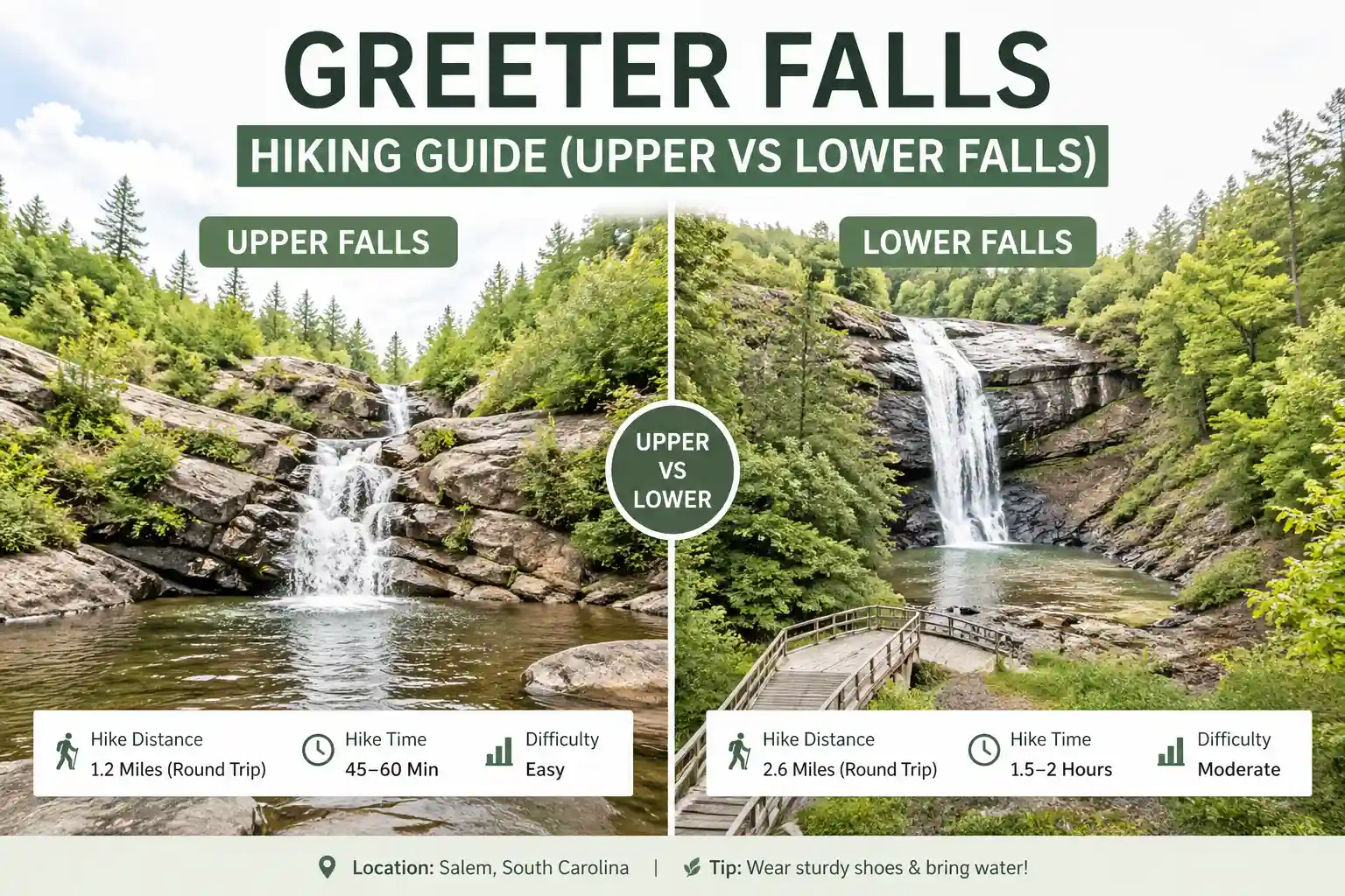
Upper Greeter Falls
Think of this as the “gateway” experience. From the Greeter Falls trailhead, it’s roughly a 0.6-mile walk each way on a well-maintained path with gentle elevation. The trail follows a creek, passes small cascades, and ends at a wide, photogenic drop.
Who it suits: Families with kids, first-time hikers, travelers with limited mobility (though the trail isn’t paved), or anyone who wants a rewarding view without technical challenges.
What to expect: Roots and rocks underfoot, a shaded canopy, and a safe viewing area near the falls. No scrambling required.
Lower Greeter Falls
This is where things get interesting—and slightly more demanding. Reaching the lower plunge typically adds another mile or more each way, with steeper sections, loose footing, and multiple unbridged creek crossings.
Who it suits: Confident hikers, photographers seeking unique angles, or travelers who enjoy route-finding and don’t mind getting their feet wet.
What to expect: Natural terrain that can get slick after rain, occasional signage gaps, and a more secluded payoff. The lower basin feels like a hidden reward.
Can You Hit Both?
Yes, but it becomes a 3.5–4.5-mile outing with moderate elevation. That’s totally doable if you start early, wear grippy footwear, and check recent weather. Just know: trying to do both on a first visit can lead to fatigue or time pressure. There’s no shame in picking one and saving the other for next time.
Making It Work: Practical Tips That Actually Help

Start early, especially on weekends. The Greeter Falls lot fills fast. If you arrive after 9 AM on a Saturday in spring, you might spend more time waiting for a spot than hiking.
Footwear matters more than distance. Even the “easier” Upper Falls trail has wet rocks and roots. Trail runners or hiking shoes with traction beat smooth-soled sneakers every time.
Download your map before you go. Service disappears in the gorge. A screenshot of the route or an offline GPS track saves stress if trail markers feel sparse.
Check rainfall history, not just the forecast. A dry morning doesn’t guarantee safe creek crossings if it rained heavily the night before. Water levels rise fast in this terrain.
Pack light, but pack smart. Water, a small snack, and a light layer go a long way. You don’t need a full backpack for Upper Falls, but skipping essentials for Lower can turn a fun hike into a stressful one.
What Most Articles Miss About Greeter Falls
A lot of posts treat Greeter Falls like a single, simple destination. “Easy waterfall hike!” they promise. But that framing skips the nuance that actually matters: your experience depends heavily on recent weather, your starting point, and which section you target.
Another gap: few guides emphasize how quickly conditions change. The same trail that’s dry and straightforward on Tuesday can be muddy and tricky by Saturday. Relying on static photos or outdated blog advice leads to mismatched expectations.
Here’s a better approach: treat your hike like a flexible plan, not a fixed checklist. If Lower Falls looks sketchy at the first creek crossing, pivot to Upper. If Upper feels too crowded, scout a quieter side trail. Adaptability beats rigid itineraries every time in this terrain.
Who Should Go Where: Matching the Trail to Your Group
Traveling with young kids? Stick to Upper Falls. Keep the outing under two hours total, bring snacks, and let them explore the creek edges safely. The shorter distance helps maintain energy and attention.
Solo or couple seeking quiet? Target Lower Falls on a weekday morning. You’ll likely have the basin to yourself, and the moderate challenge adds a satisfying sense of accomplishment.
Chasing photos? Overcast days actually work in your favor—soft light reduces harsh shadows on waterfall shots. Early morning gives you the best chance at empty viewpoints.
Limited mobility or joint concerns? Upper Falls is the more viable option, though still uneven in sections. If stability is a concern, trekking poles can help on the descent and return climb.
Real Questions, Straight Answers
Are dogs allowed?
Yes, leashed pets are welcome. Just know that creek crossings and rocky sections near Lower Falls can be tough for small or older dogs. Bring extra water for them.
Is swimming okay?
It’s not officially banned, but it’s not encouraged either. Rocks get slick, currents can surprise you, and water stays cold. Most visitors enjoy the view from safe vantage points—and that’s usually more rewarding anyway.
What if I’m not a strong hiker?
Upper Falls is absolutely doable. Take your time, wear supportive shoes, and turn back whenever you feel ready. The goal is enjoyment, not endurance.
Do I need special gear?
Not for Upper Falls. For Lower, grippy footwear and a small backpack for water/snacks make a noticeable difference. Trekking poles help on steeper sections, but aren’t required.
How crowded does it get?
Spring and fall weekends see the most traffic. Weekday mornings offer the best chance for solitude. If you show up at noon on a Saturday in October, expect company.
A Quick Word on Preparation
Before you head out, spend five minutes checking the official South Cumberland State Park website for trail alerts. Conditions shift. A quick verification beats a wasted drive.
Also: tell someone your plan. Even short hikes in this area can surprise you. A quick text with your intended route and return time adds a layer of safety without complicating your day.
Practical Recommendations
If you’re visiting Greeter Falls for the first time, here’s a straightforward approach: start at the Greeter Falls trailhead, hike to Upper Falls, and see how you feel. If the weather’s dry, your energy is good, and you’re curious to explore further, continue toward Lower. If not, you’ve already seen a beautiful waterfall with minimal effort.
For repeat visitors or confident hikers, consider starting at Foster Falls and linking Greeter Falls into a longer Fiery Gizzard loop. That route offers more variety, but also demands more preparation.
When in doubt, prioritize safety over summiting. Turning back early isn’t failure; it’s smart hiking.
Leave a Reply