
Pacific Coast Highway Road Trip: 7-Day Itinerary, SF to San Diego
Seven days, about 600 miles, and the most famous coastline in America. A day-by-day Pacific Coast Highway itinerary with honest driving times, where to sleep and what to skip.
Drive the Pacific Coast Highway from San Francisco to San Diego in seven days, north to south, with at least one night in Big Sur. That pace keeps most driving days to two or three hours across roughly 600 miles. Two days is possible. It is also a waste of the best coastline in America. Check Caltrans QuickMap before you leave, because landslides have closed parts of Highway 1 through Big Sur repeatedly in recent years.
You can drive the whole thing in two long days. Please don’t. This seven-day itinerary keeps most driving days around two to three hours so you have time to actually stop, walk, eat and watch the sunset. It covers roughly 600 miles including detours, and it works in either direction. We recommend north to south so the ocean is on your side of the car and every pullout is an easy right turn.
- ≈600 miSan Francisco to San Diego
- 7 daysWithout rushing
- North → southOcean-side lane
- Apr–OctBest weather window
Before you go: three things to check
1. Big Sur road status
Highway 1 through Big Sur is built into steep, unstable mountainsides, and landslides have closed sections of it repeatedly in recent years, sometimes for months. A closure can turn a short drive into a long inland detour on Highway 101. Check Caltrans QuickMap the week before and the morning you drive. If part of Big Sur is closed, you can usually still reach the open stretches from either end and backtrack.
2. Gas and signal
Gas stations in Big Sur are few and expensive. Fill up in Carmel or Monterey heading south, or in Cambria heading north. Cell service disappears for long stretches between Carmel and Ragged Point, so download offline maps and your hotel confirmations ahead of time.
3. Weather and fog
Summer on the central coast often means morning fog, the famous “June gloom,” that may not burn off until afternoon. September and October often bring the clearest, warmest coastal weather. Winter storms are the main cause of road closures. Pack layers: a sunny 75 °F afternoon can turn into a foggy 55 °F evening in an hour.
The route at a glance
| Day | Route | Approx. miles | Drive time | Sleep in |
|---|---|---|---|---|
| 1 | San Francisco → Santa Cruz | 75 | 2 hr | Santa Cruz |
| 2 | Santa Cruz → Monterey & Carmel | 45 | 1 hr | Monterey or Carmel |
| 3 | Carmel → Big Sur | 30–60 | 1–2 hr | Big Sur |
| 4 | Big Sur → Cambria / San Simeon | 65–90 | 2–3 hr | Cambria |
| 5 | Cambria → Santa Barbara | 130 | 2.5 hr | Santa Barbara |
| 6 | Santa Barbara → Malibu → Los Angeles beaches | 100 | 2.5 hr | Santa Monica or Laguna |
| 7 | Los Angeles → Laguna → San Diego | 120 | 2.5–3 hr | San Diego |
Drive times are without stops and without heavy traffic, which you will absolutely hit around Los Angeles.
Day 1: San Francisco to Santa Cruz
Leave the city by mid-morning on Highway 1 through Pacifica. Within half an hour the suburbs fall away and you are on the cliffs above Devil’s Slide, now a coastal trail you can walk where the old road used to run. Half Moon Bay is a good coffee stop, especially in October when the pumpkin farms are in full swing.
Continue south past Pescadero and stop at Pigeon Point Lighthouse, one of the tallest lighthouses on the West Coast. Tide pools nearby are excellent at low tide. In winter and early spring, Año Nuevo State Park hosts a huge elephant seal colony, visited on guided walks during breeding season, so reserve ahead.
End the day in Santa Cruz. Walk West Cliff Drive at sunset, watch surfers at Steamer Lane and, if you have the energy, ride the 1924 Giant Dipper wooden roller coaster at the Santa Cruz Beach Boardwalk.
Day 2: Santa Cruz to Monterey and Carmel
This is a short driving day with plenty to see. Stop at Moss Landing to see sea otters floating in rafts in Elkhorn Slough. A kayak tour gets you closer, but stay at a respectful distance. Continue to Monterey for the Monterey Bay Aquarium, one of the best aquariums in the world, and a walk along Cannery Row.
In the afternoon, drive the 17-Mile Drive through Pebble Beach, a private toll road past cypress trees, rocky coves and the famous Lone Cypress, or skip the fee and walk the free coastal path in Pacific Grove instead. End in Carmel-by-the-Sea, a storybook village with no street addresses, art galleries and a white-sand beach that is perfect at sunset.
Day 3: Big Sur
This is the day the trip is built around. Big Sur is less a town than a 90-mile stretch of wild coast between Carmel and San Simeon. Take it slowly.
- Point Lobos State Natural Reserve: just south of Carmel, often called the crown jewel of the state park system. Arrive early because parking is limited.
- Bixby Creek Bridge: the famous concrete arch bridge, built in 1932. The small turnouts on the north side fill quickly, so go early or simply enjoy driving across it.
- Pfeiffer Big Sur State Park: redwoods, river swimming holes and short trails.
- Pfeiffer Beach: reached by a narrow, unmarked road, Sycamore Canyon Road, off Highway 1. It is known for purple-tinged sand and a rock arch called Keyhole Rock. Large vehicles and trailers are not permitted on the road.
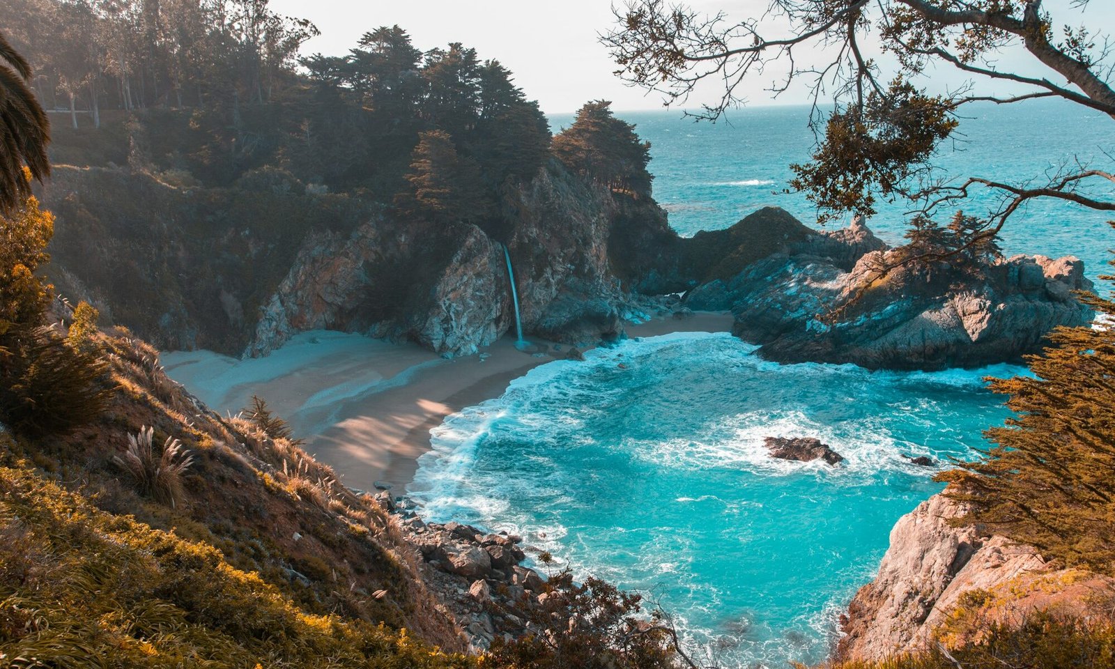
- McWay Falls: in Julia Pfeiffer Burns State Park, an 80-foot waterfall that falls onto a beach. A short, easy trail leads to the overlook. The beach itself is closed to visitors.
Sleep in Big Sur if your budget allows. Options range from campgrounds to rustic cabins to luxury resorts, and all of them book up months ahead for summer weekends. If Big Sur is full or too pricey, stay in Carmel and drive down for the day.
Use turnouts to let faster traffic pass. It is courteous and required when five or more cars are behind you. Never stop on the road itself for photos. Watch for cyclists on blind curves, and keep headlights on in fog.
Day 4: Big Sur to Cambria and San Simeon
Continue south through the quieter southern half of Big Sur. Stop at Ragged Point for coffee and a cliff-top view. A few miles past San Simeon, pull into the Piedras Blancas elephant seal rookery. Thousands of elephant seals haul out on the beach here, viewable for free from a boardwalk. Activity peaks in winter during breeding season, but you will usually see seals any time of year.
In the afternoon, tour Hearst Castle, newspaper magnate William Randolph Hearst’s hilltop estate, now a state historic park. Book tours online in advance. Spend the night in Cambria, a pretty village of pines and boardwalks above Moonstone Beach. Don’t leave without trying a slice of olallieberry pie, a Central Coast specialty.
Day 5: Cambria to Santa Barbara
Head south past Morro Bay, where the 576-foot volcanic plug of Morro Rock rises from the harbor. Kayaking around the bay early in the morning, when the water is glassy, is a highlight. Sea otters are common. Continue through San Luis Obispo and Pismo Beach, where you can stop for clam chowder.
Highway 1 joins Highway 101 for much of this stretch. If the inland section feels routine, detour through the Santa Ynez Valley wine country around Los Olivos and Solvang, a Danish-style village. Arrive in Santa Barbara for the evening. Walk State Street and Stearns Wharf, then eat in the Funk Zone, a converted warehouse district full of tasting rooms and restaurants.
Day 6: Santa Barbara to Malibu and the Los Angeles beaches
Follow the coast through Carpinteria and Ventura, then rejoin Highway 1 at Oxnard. The stretch through Point Mugu and into Malibu is gorgeous. Stop at El Matador State Beach for sea stacks and coves, then at Point Dume for a short walk and whale-watching from the headland in winter and spring.
Continue to Santa Monica and the pier, which marks the official end of Route 66. Bike or walk the beach path south to Venice. If you would rather skip the city, keep driving to the beach towns of the South Bay or Laguna Beach and sleep there. Plan your timing around traffic and avoid driving through Los Angeles during weekday rush hours.
Day 7: Laguna Beach to San Diego
Spend the morning in Laguna Beach, with tide pools at Crescent Bay and the coves along Heisler Park. Head south through Dana Point and San Clemente. The Pacific Coast Highway name officially ends in Southern California, but the coast keeps going. Stop in Encinitas or Del Mar, then finish at La Jolla Cove, where sea lions and harbor seals lounge on the rocks. End in San Diego with fish tacos, which by now you are qualified to rank.
How much does the trip cost?
Costs vary hugely by season and comfort level. For two people sharing a car and a room, a realistic mid-range budget for seven nights looks like this:
- Lodging (7 nights, mix of motels and inns): $1,400–$2,400.
- Rental car (one-way, 7 days, incl. fees): $450–$900.
- Gas (≈650 miles incl. detours): $120–$200.
- Food and drinks: $700–$1,100.
- Attractions (aquarium, Hearst Castle, parking, parks): $150–$300.
- Total: $2,800–$4,900.
One-way rentals between Northern and Southern California often add a drop fee, so compare that against a round trip. For a deeper breakdown and money-saving tactics, read our guide to what a US road trip really costs.
Where to stay: quick picks by budget
- Budget: state park campgrounds (book far ahead), independent motels in Santa Cruz, Morro Bay and Ventura, and hostels in San Francisco and San Diego.
- Mid-range: inns in Pacific Grove and Cambria, and beach hotels in Pismo and Ventura.
- Splurge: cliffside resorts in Big Sur, boutique hotels in Carmel and Santa Barbara.
Book Big Sur first, since it is the hardest to find, and build the rest of the route around it. Our hotel booking guide explains how to rebook when prices drop.
Best time to drive the Pacific Coast Highway
- April–May: wildflowers on the hills, green landscapes, fewer crowds outside spring break.
- June–August: peak season, busiest and priciest, with morning fog on the central coast.
- September–October: our favorite, with the warmest, clearest coastal weather and smaller crowds after Labor Day.
- November–March: quiet and cheaper, with whale migration and elephant seal season, but a higher risk of storms and road closures.
Detours worth adding
If you have extra days, these detours turn a great coastal drive into an unforgettable California trip:
- Muir Woods and Point Reyes: start north of San Francisco instead, with old-growth redwoods and the wild Point Reyes peninsula, then cross the Golden Gate Bridge southbound.
- Pinnacles National Park: about an hour inland from Monterey, with talus caves and condors. It is a good escape on foggy coastal days.
- Paso Robles wine country: 30 minutes inland from Cambria, with hundreds of wineries and warm, sunny weather when the coast is gray.
- Channel Islands National Park: boats from Ventura reach Santa Cruz Island for a day of kayaking, hiking and island foxes. Book ahead.
- Yosemite: combine the coast with the Sierra on a two-week loop. Our Yosemite guide helps you pick the right month.
What to pack
- Layers: a warm fleece and a windproof jacket, even in summer.
- Comfortable walking shoes and sandals for the beach.
- Binoculars for whales, otters and seals.
- Reusable water bottle and snacks for Big Sur, where stores are scarce.
- A car phone mount and a charging cable, plus offline maps.
- Our full road trip packing list for everything else.
Frequently asked questions
How many days do you need for the Pacific Coast Highway?
Five days is the minimum for San Francisco to San Diego without feeling rushed. Seven days lets you enjoy Big Sur, the Central Coast and the beach towns properly.
Is it better to drive the PCH north to south or south to north?
North to south. You drive in the lane closest to the ocean, which gives better views and makes pulling into turnouts easier.
Is Highway 1 through Big Sur open?
Sections have been closed by landslides in recent years. Check Caltrans QuickMap for current conditions before you drive.
Where is the most beautiful part of the Pacific Coast Highway?
Most travelers agree it is Big Sur, especially between Bixby Creek Bridge and McWay Falls.
Eric Gamble
Eric Gamble is the founder of Travon Inc. and editor-in-chief of Travon Blog, based in New Orleans. He plans every guide around the questions travelers actually ask before they book: when to go, what it really costs, how to get around and what is worth skipping. Eric oversees research, fact-checking and the regular updates that keep each guide accurate.
1 comment